Geiskeli
| Markierung: |  |
Schwierigkeit: | Mittel |
| Länge: | 5.7 km | Status: | Geschlossen |
| Rundloipe: | nein |
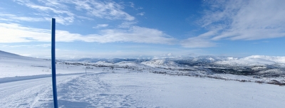

Blick von der Geiskeli-Loipe in Richtung Geiskeli
Foto: Jan Mielke
Foto: Jan Mielke
Zurück zur Übersichtskarte
Loipenstatistik
| Höhendifferenz: | 1147 m | ||
| Niedrigst. Punkt: | 0 m | Höchst. Punkt: | 1147 m |
| Höhenmeter aufwärts: | 1194 m | Höhenmeter abwärts: | 821 m |
| Steilst. aufwärts: | 1325.8 % | Steilst. abwärts: | 1767.4 % |
| Längst. aufwärts: | 3993 m | mit einer Höhendiff. von 14 m | |
| Längst. abwärts: | 206 m | mit einer Höhendiff. von 6 m | |
| Steigung/Gefälle | >15% | 10% - 15% | 5% - 10% |
| Aufwärts | 1044 m | 1457 m | 1968 m |
| Abwärts | 814 m | 0 m | 0 m |
| Eben (±4%) | 1997 m |